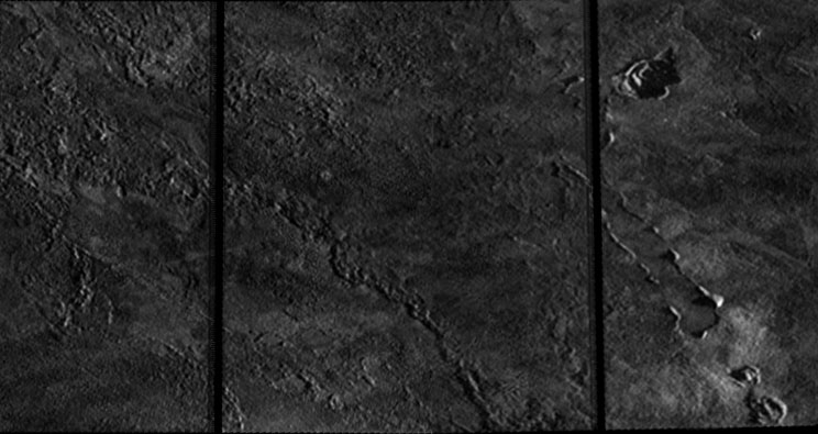
 I've started processing some of the mosaics from the Galileo I24 flyby that took place on October 11, 1999. Most of the images acquired during this flyby were taken in 2x2 summation mode, so the images had half the resolution of normal mode images. Unfortunately, an error in the camera, that began on the previous orbit, caused these images to become scrambled. Luckily, an algorithm was developed that reconstructed the scrambled images.
So tonight I started working through some of these for my images page, particularly the 24ISPILLAN01, 24ISCOLCHS01, and 24ISZAMAMA01 mosaics. Ordinarily, I would initially process these images in ISIS before piecing the mosaics together in Photoshop. Unfortunately, these reconstructed images aren't fully in PDS-compatible format so ISIS can work with them beyond the initial conversion to ISIS. So I can't reproject them, which would make it easier to piece them together. So everything was done in Photoshop, piecing them together and adjusting each image so that they would fit together. I think the results turned out pretty well.
24ISPILLAN01 covers a lava flow that formed during the summer of 1997 north of Pillan Patera on Io's trailing hemisphere. The flow can be seen as the darker material on the western two-thirds of the mosaic. According to Williams et al. 2001, the lava flow appears to have been emplaced as a turbulent sheet flow, with few apparent channels. Several pits are also seen that maybe rootless cones, formed from the interaction between the hot, flowing lava and the sulfurous frost beneath. On the eastern third of the mosaic, the terrain that existed before eruption can be seen. It appears hummocky with at least one apparent flow margin, suggestive of a prior eruption at this location. It isn't certain if the hummocky nature of the surface existed before the 1997 eruption, or if it is related to pyroclastic processes that occurred during that event.
24ISCOLCHS01 is a high-resolution mosaic covering Ot Mons in the central part of Colchis Regio. The mountain is covered in numerous hummocks, similar to the surface of the northern component of Hi'iaka Montes, and is likely related to the degradation of the mountain.
24ISZAMAMA01 covers the southern portion of the Zamama lava flow (a major volcanic center during the 1990s) and the surrounding terrain. The Zamama vent is just to the upper left of the mosaic and is surrounded by lava flows radiating out from it (see this image from the 24ISZAMAMA02 observation for context). The toes of some of the flows that radiate south can be seen at the far left hand side of the mosaic. To the east of those are bright, incised channels that might be related to sulfur volcanism. Portions of the main Zamama lava flow can be seen through the rest of the mosaic. This flow has a relatively bland surface with crenulated margins.
There are plenty more mosaics to work on but it is getting quite late here. Hope you all enjoy these.
Link: Galileo I24 images [pirlwww.lpl.arizona.edu]






i am wondering if you know the range of distance for these?
ReplyDeleteHere are the approximate range to target distances. I believe these correct for the oblique viewing angle for some of the higher resolution images:
ReplyDelete24ISPILLAN01: 950 km
24ISCOLCHS01: 750-950 km
24ISZAMAMA01: 1850-2050 km